Responsive OneMap UI using media query and flex box

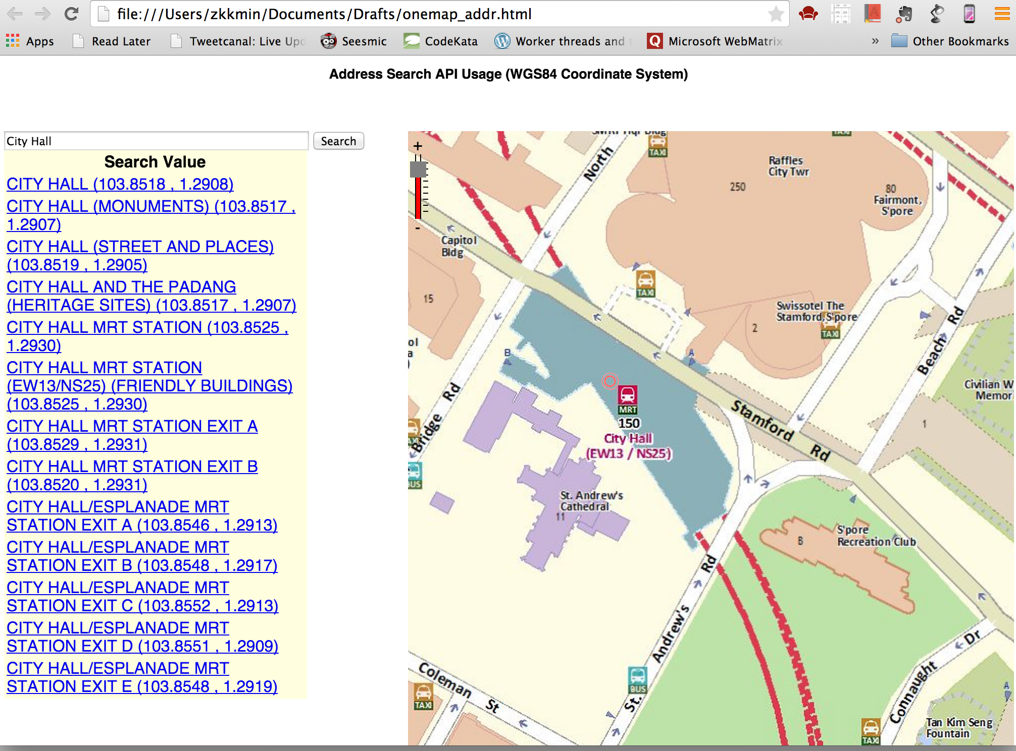
In this tutorial, I will show you how to make responsive UI for web page using flex boxes and media query. I will redesign one of the examples available on OneMap API Help Web Site. We will see how to make pages using OneMap JavaScript API responsive. Please visit the OneMap API address search example  to check the original web page.

onemap_add_eg 1) Inspect the source code


<table style="width: 436px">
<tr>
<th colspan="2">
Address Search API Usage (WGS84 Coordinate System)
</th>
</tr>
<tr>
<td>
Search Text :
</td>
<td>
<input type="text" id="txtSearchText" value='City Hall' />
</td>
</tr>
<tr>
<td>
<input type="button" onclick="GetSearchData();" value="Search" />
</td>
</tr>
</table>
<table>
<tr>
<td>
<div id="divMain" style='width: 500px; height: 500px;'>
</div>
</td>
<td style="vertical-align: top">
<div id="divResults">
</div>
</td>
</tr>
</table>

view raw

gistfile1.html

hosted with ❤ by GitHub

By inspecting the source code, I found that the page is designed using HTML Table. It is quite a simple page with only a few sections, each section embedded in  table cell. I am going to use media query and flex boxes to make the page responsive.

2) Put viewport meta tag in the head of the document.


<meta name="viewport" content="width=device-width, initial-scale=1.0" />

view raw

gistfile1.html

hosted with ❤ by GitHub

width=device-width” indicates the screen’s width in device independent pixels. “initial-scale=1.0” to indicates one to one relationship between CSS and device independent pixels.

3) Convert the HTML Table structure into separate sections as follow.


<div class="container">
<div class="box heading">
<h2>Address Search API Usage (WGS84 Coordinate System)</h2>
</div>
<div class="box container2">
<div class="box searchbox">
<input type="text" id="txtSearchText" value='City Hall' />
<input type="button" onclick="GetSearchData();" value="Search" />
</div>
<div class="box results">
<div id="divResults">
</div>
</div>
</div>
<div class="box map">
<div id="divMain" >
</div>
</div>
</div>

view raw

gistfile1.html

hosted with ❤ by GitHub

.searchbox and .results are put into .container2 so that they could be moved around together when the screen size becomes bigger.

4) Design smallest view first and use media query for different break points.


/* set padding and height to 100% */
html, body, #mapDiv {
padding: 0;
margin: 0;
height: 100%;
font-family: sans-serif;
}
/* use flex and flex-wrap */
.container {
display: flex;
flex-wrap: wrap;
height: 100%;
}
/* set all the section stacked vertically in mobile view*/
.box {
width: 100%;
}
.heading {
font-size: 1.0em;
text-align: center;
min-height: 50px;
}
.heading h2{
font-size: smaller;
}
.map {
height: 80%;
max-height: 700px;
}
#txtSearchText {
width: 74%;
}
#btnSearch {
width: 20%;
}
#divMain{
width: 100%;
height: 100%;
}
/* results will be off the screen at first
when the search button is pressed,
it will slide in from the left.
*/
#divResults{
overflow:scroll;
width: 300px;
height: 100%;
position: absolute;
transform: translate(-300px, 0);
transition: transform 0.3s ease;
background-color: lightyellow;
}
/* Set this property from javascript to make the results
to slide into view */
#divResults.open {
transform: translate(0,0);
z-index: 101;
}
/* adjust the logo at the bottom of map */
#OneMapLogo {
bottom: 5px;
}

view raw

gistfile1.css

hosted with ❤ by GitHub

onemap_min

5) Slide in the results on the screen when the user clicked the search button.


function displayData(resultData) {
var results = resultData.results;
if (results == 'No results') {
document.geElementById('divResults').innerHTML = "No result(s) found";
return false
}
else {
// Set the divResults class as open to slide in from off screen
var drawer = document.getElementById("divResults");
drawer.classList.toggle('open');
/////
var htmlStr = "<table>";
htmlStr = htmlStr + "<tr><th>Search Value </th></tr>";
for (var i = 0; i < results.length; i++) {
var row = results[i];
htmlStr = htmlStr + "<tr>";
htmlStr = htmlStr + "<td>";
htmlStr = htmlStr + "<a href='JavaScript:ZoomTo(" + row.Y + "," + row.X + ")'>" + row.SEARCHVAL + " (" + parseFloat(row.X).toFixed(4) + " , " + parseFloat(row.Y).toFixed(4) + ")" + "</a>";
htmlStr = htmlStr + "</td>";
htmlStr = htmlStr + "</tr>";
}
htmlStr = htmlStr + "</table>";
document.getElementById("divResults").innerHTML = htmlStr;
}
}

view raw

gistfile1.js

hosted with ❤ by GitHub

Edit the displayData( ) function as above to slide in the divResults into the view.

6) Slide back and hide the results list when the user clicked on one of the result, and then show the clicked location on the map. 

Add the following code to ZoomTo( ) function to hide the list.


function ZoomTo(xVal, yVal) {
// Remove the class open from divResults,
// so that it will slide back out of view
var drawer = document.getElementById("divResults");
drawer.classList.toggle('open');
///
OneMap.showLocation(xVal, yVal);
}

view raw

gistfile1.js

hosted with ❤ by GitHub

7) Add media query and styles for break point with minimum width 800px.


@media screen and (minwidth: 800px){
.container2 {
width :40%;
}
.map {
width : 60%;
}
#divResults{
position: relative;
transform: translate(0,0);
}
}

view raw

gistfile1.js

hosted with ❤ by GitHub

In a wider screen, container2, which contains search input box and result list, and map area are placed side by side. Result list is put back on screen by setting transform to 0,0.

onemap_800_min

8) Add media query and styles for break point with minimum width 1000px.

After minimum width 1000px is reached, the contents will stop growing, and left and right margins will be added automatically.


@media screen and (min-width: 1000px){
.container {
width: 1000px;
margin-left: auto;
margin-right: auto;
height: 800px;
}
.map {
height: 700px;
}
.heading {
height: 20px;
}
}

view raw

gistfile1.css

hosted with ❤ by GitHub

onemap_maximum

That is! We have a responsive page using OneMap as base-map. This is just a very simple rework on the existing code and by no means a complete work. But you get the basic idea of how to make your page responsive if you are using onemap api in it.

Using OneMap Address Search in iOS App

In this tutorial, we are going to implement the address search feature using OneMap REST API. If you want to know more about OneMap, please visit to OneMap API Help page.

We will continue our tutorial from my post how to add OneMap to iOS App, in which I’ve shown how to use ArcGIS iOS SDK and adding OneMap base map and setting map extent. Complete the steps in it before attempting this tutorial.

We are going to call the Address Search REST API from OneMap form our iOS app. I’ve tried out the API call and explored the data returned from the service in previous post Exploring OneMap REST API with Swift Playgrounds.

Add Navigation Controller
First, we need to add Navigation controller to our View Controller. Go to Editor > Embed In > Navigation Controller. A Navigation Controller is added to our View Controller.

Embed in navigation

Add UISearchController And UITableViewController
We are going to use the UISearchController to allow users to key in address. The results will be shown in UITableViewController as the user type in the key words. Add UISearchController property and UITableViewController property in the View Controller.


var resultTableViewController = UITableViewController()
var searchController = UISearchController()

view raw

gistfile1.swift

hosted with ❤ by GitHub

In the viewDidLoad( ) method, add following setup code for UISearchController.


// UISearchController Setup
searchController = UISearchController(searchResultsController: resultTableViewController)
searchController.searchResultsUpdater = self
searchController.searchBar.searchBarStyle = UISearchBarStyle.Minimal
searchController.hidesNavigationBarDuringPresentation = false
navigationItem.titleView = searchController.searchBar
definesPresentationContext = true
resultTableViewController.tableView.dataSource = self
resultTableViewController.tableView.delegate = self
searchController.dimsBackgroundDuringPresentation = false
searchController.delegate = self
searchController.searchBar.delegate = self

view raw

gistfile1.swift

hosted with ❤ by GitHub

Next, add the necessary delegates to View Controller as follow:


// delegates for AGSMapViewLayer, UISearchController, UITableView
class ViewController: UIViewController, AGSMapViewLayerDelegate,
UISearchResultsUpdating, UITableViewDelegate,
UITableViewDataSource, UISearchControllerDelegate,
UISearchBarDelegate {

view raw

gistfile1.swift

hosted with ❤ by GitHub

Create a data structure to hold the address data
Create a structure named Place to hold address name, category, X and Y.


struct Place {
var placeName = ""
var Category = ""
var X = 0.0
var Y = 0.0
}

view raw

gistfile1.swift

hosted with ❤ by GitHub

In ViewController, declare an array of Places. This array will be our data model to store the search results.


var searchResults = [Place]()

view raw

gistfile1.swift

hosted with ❤ by GitHub

Implement UITableView delegate protocol methods 
There are three protocol methods we need to implement to adopt the UITableView delegate protocol. Add the following methods to ViewController Class.


// UITableView delegate protocol methods
func tableView(tableView: UITableView, didSelectRowAtIndexPath indexPath: NSIndexPath) {
searchController.searchBar.text = searchResults[indexPath.row].placeName
showSelectedSearchPlace(searchResults[indexPath.row])
}
func tableView(tableView: UITableView, cellForRowAtIndexPath indexPath: NSIndexPath) -> UITableViewCell {
let rowData = searchResults[indexPath.row].placeName
let cell = UITableViewCell()
cell.textLabel?.text = rowData
return cell
}
func tableView(tableView: UITableView, numberOfRowsInSection section: Int) -> Int {
return searchResults.count
}

view raw

gistfile1.swift

hosted with ❤ by GitHub

Implement UISearchResultsUpdating delegate protocol method
UISearchResultsUpdating protocol requires to implement the following method. This allow us to update search results based on the information users enters in the search bar.


func updateSearchResultsForSearchController(searchController: UISearchController) {
getAddresses(searchController.searchBar.text)
}

view raw

gistfile1.swift

hosted with ❤ by GitHub

Next, we will implement the function to call OneMap REST API to search for the address.


// Call OneMap's Address Search API to search a location in Singapore
func getAddresses(keyWord: String ){
if keyWord != "" {
let keyWordEscaped = keyWord.stringByAddingPercentEscapesUsingEncoding(NSUTF8StringEncoding)
let urlString = "http://www.onemap.sg/API/services.svc/basicSearch?token=qo/s2TnSUmfLz+32CvLC4RMVkzEFYjxqyti1KhByvEacEdMWBpCuSSQ+IFRT84QjGPBCuz/cBom8PfSm3GjEsGc8PkdEEOEr&wc=SEARCHVAL%20LIKE%20%27\(keyWordEscaped!)$%27&otptFlds=CATEGORY&returnGeom=0&nohaxr=10"
session.dataTaskWithURL(NSURL(string: urlString)!, completionHandler: {
(taskData, taskResponse, taskError) -> Void in
var jsonReadError : NSError?
var jsonResult = NSJSONSerialization.JSONObjectWithData(taskData, options: NSJSONReadingOptions.MutableContainers, error: &jsonReadError) as NSDictionary
let resultsArray = jsonResult["SearchResults"] as NSArray
self.searchResults = []
for (index, result) in enumerate(resultsArray){
if index > 0 {
var place = Place()
if let placeName = result["SEARCHVAL"] as String? {
place.placeName = placeName
}
if let category = result["CATEGORY"] as String? {
place.Category = category
}
if let x = result["X"] as NSString? {
place.X = x.doubleValue
}
if let y = result["Y"] as NSString? {
place.Y = y.doubleValue
}
self.searchResults.append(place)
}
}
self.resultTableViewController.tableView.reloadData()
}).resume()
}
}

view raw

gistfile1.swift

hosted with ❤ by GitHub

Run the application
If everything goes well, a search bar will be displayed on the navigation controller title place.

searchbar

When the user type in the search keywords in the search bar, getAddresses function is called and a list of addresses started by the keyword is shown in the table view as suggestion.

Auto suggestion

Show the selected one on the map view
We need to implement one more function to show the search result when the user clicks on one of the suggested places. This function is called in tableView:didSelectRowAtIndexPath: delegate method.


func showSelectedSearchPlace(selectedPlace :Place){
// to close suggested list when the user selected one
searchController.active = false
searchController.searchBar.text = selectedPlace.placeName
// a red color symbol to mark the place
let myMarkerSymbol = AGSSimpleMarkerSymbol()
myMarkerSymbol.color = UIColor.redColor()
// a point representing x,y data from selctedPlace
let point = AGSPoint(x: selectedPlace.X, y: selectedPlace.Y, spatialReference: mapView.spatialReference)
// make the selectedPlace at the center of the map
mapView.centerAtPoint(point, animated: false)
// make a graphic with symbol and point to add to the map
var pointGraphic = AGSGraphic(geometry: point, symbol: myMarkerSymbol, attributes: nil)
// remove previously searched places
graphicLayer.removeAllGraphics()
// display the graphic on the map
graphicLayer.addGraphic(pointGraphic)
}

view raw

gistfile1.swift

hosted with ❤ by GitHub

showaddress

Above screen is shown when the user selects City Hall from suggested addresses. The project is available on github. Please leave comments if you have any questions and suggestion.

Using OneMap in iOS map application

I am learning Swift, the new programming language developed by Apple for iOS and OSX application development, and ArcGIS iOS SDK. I am planning  to make a series of tutorials based on what I have learned progressively.

In this tutorial, I am going to show you how to use Singapore’s official map platform, OneMap (www.onemap.sg), in iOS 8 application.

OneMap is an integrated map system for government agencies to deliver location-based services and information. It is a multi-agency collaboration with many government agencies currently participating and contributing information. ~ http://www.onemap.sg/home

To use OneMap in our iOS app, we need to use ArcGIS iOS SDK from Esri.  First download the ArcGIS SDK for iOS from https://developers.arcgis.com/ios/. Follow the guide to install and setup the development environment. ArcGIS has a very comprehensive guide for installing and setting up the development environment.

To use OneMap, first you need to add a UIView to your storyboard. In the Identity Inspector, change the UIView class name to AGCMapView.

MapView

Connect the map view to the view controller by creating an outlet in in ViewController.swift file.

Outlet

Import the ArcGIS framework in view controller’s swift file to use ArcGIS SDK for ios.


// import ArcGIS framework
import UIKit
import ArcGIS

view raw

import_arcgis

hosted with ❤ by GitHub

In the viewDidLoad method of ViewController.swift file, create a tiled map layer using OneMap map service and add it to the map:


override func viewDidLoad() {
super.viewDidLoad()
// set OneMap base map url
let url = NSURL(string: "http://e1.onemap.sg/arcgis/rest/services/BASEMAP/MapServer")
// create a tiled map layer
let tiledLayer = AGSTiledMapServiceLayer(URL: url)
// add layer to the mapView UIView
self.mapView.addMapLayer(tiledLayer, withName: "Basemap Tiled Layer")
}

view raw

gistfile1.swift

hosted with ❤ by GitHub

Run the application and you will see the map application displaying onemap.sg base map in the map view.

Initial Run

Right now, our map displays the whole Singapore, but we want it to be focus on a particular area in Singapore when it is loaded. To do this we need to define the initial map extent to zoom in display. We need to pass the envelope geometry to the  zoomToEnvelope:animated: method to zoom to the area we are interested in. 

An envelope is defined by a pair of X-Y coordinates representing the lower-left and upper-right corners of a rectangular bounding-box.

To create an envelope geometry, we need X min, Y min, X max and Y max. How do we find out this values? Pretty easy. We can get the current map’s extent from mapView.visibleAreaEnvelope property. So we just have to zoom in to the area of interest and inspect the current mapView.visibleAreaEnvelope values and use them as the initial extent in viewDidLoad method.

Our View Controller must adapt to the  AGSMapViewLayerDelegate protocol and set itself as the delegate of mapView‘s layerDelegate.


class ViewController: UIViewController, AGSMapViewLayerDelegate {

view raw

gistfile1.swift

hosted with ❤ by GitHub

In the viewDidLoad method, add this line to set delegate. See the API reference documentation for the AGSMapViewLayerDelegate protocol to learn more on layerDelegate


self.mapView.layerDelegate = self

view raw

gistfile1.swift

hosted with ❤ by GitHub

Then implement mapViewDidLoad delegate method to add observer for mapView pan and zoom notifications.


func mapViewDidLoad(mapView:AGSMapView!){
NSNotificationCenter.defaultCenter().addObserver(self, selector: "responseToEventChanged:", name: AGSMapViewDidEndZoomingNotification, object: nil)
}
func responseToEventChanged(notification: NSNotification){
let theString = "xmin = \(mapView.visibleAreaEnvelope.xmin),\nymin = \(mapView.visibleAreaEnvelope.ymin),\nxmax = \(mapView.visibleAreaEnvelope.xmax),\nymax = \(mapView.visibleAreaEnvelope.ymax)"
println(theString);
}

view raw

gistfile1.swift

hosted with ❤ by GitHub

Run the application and zoom to the area you want to show on initial start up. As you zoom in to the area, you can see then envelope geometry data printed out in Xcode console. When you are satisfied with the view, copy the X min, Y min, X max and Y max from the console and use them as initial extent.

I choose Nanyang Polytechnic as my starting view and create an envelop geometry from it. Following is the complete code:


import UIKit
import ArcGIS
class ViewController: UIViewController, AGSMapViewLayerDelegate {
@IBOutlet weak var mapView: AGSMapView!
let xmin = 29495.9472786567
let ymin = 39801.9418330241
let xmax = 30037.5707551916
let ymax = 40765.3094566208
override func viewDidLoad() {
super.viewDidLoad()
// add base map
let url = NSURL(string: "http://e1.onemap.sg/arcgis/rest/services/BASEMAP/MapServer")
let tiledLayer = AGSTiledMapServiceLayer(URL: url)
self.mapView.addMapLayer(tiledLayer, withName: "Basemap Tiled Layer")
self.mapView.layerDelegate = self
let envelope = AGSEnvelope(xmin: xmin, ymin: ymin, xmax: xmax, ymax: ymax, spatialReference: self.mapView.spatialReference);
self.mapView.zoomToEnvelope(envelope, animated: false)
}
func mapViewDidLoad(mapView:AGSMapView!){
NSNotificationCenter.defaultCenter().addObserver(self, selector: "responseToEventChanged:", name: AGSMapViewDidEndZoomingNotification, object: nil)
}
func responseToEventChanged(notification: NSNotification){
let theString = "xmin = \(mapView.visibleAreaEnvelope.xmin),\nymin = \(mapView.visibleAreaEnvelope.ymin),\nxmax = \(mapView.visibleAreaEnvelope.xmax),\nymax = \(mapView.visibleAreaEnvelope.ymax)"
println(theString);
}
}

view raw

gistfile1.swift

hosted with ❤ by GitHub

Mat on NYP

In this tutorial, we have learned how to add OneMap as based map to the iOS application and setting up initial map extent to the location of interest by using envelop geometry. If you want to know more about OneMap features and services, please visit to their API help page http://www.onemap.sg/api/help/.

Look forward for more tutorials on using OneMap from me and please leave a comment if you find any error or have difficulty following the steps above.

Simple site monitoring and alerting using Python & Twilio SMS

My company has a website with mostly static contents running on an old Linux machine. We hardly need to update the contents over a long period of time and everyone forgot about it. Then we got complaints from users as the site went down for a while. We fixed the problem and got back the site up in no time but it was quite embarrassing.

So I decided to implement a simple monitoring and alert system for future breakdown since the box is like really really old. I wrote a Python script to make requests to web pages and give out alert via sms if failed. For sms alert I used Twilio API.


import urllib
from twilio.rest import TwilioRestClient

def send_sms(urlstr, msg_string):
	account_sid = "xxxxxxxxxxxxxxxxxxxxxxxxxxxxxx"
	auth_token = "xxxxxxxxxxxxxxxxxxxxxxxxxxxxxxx"
	client = TwilioRestClient(account_sid, auth_token)

	message = client.sms.messages.create(body="Server Status (%s) : %s" % (urlstr, msg_string) , to="RECEIVER NUMBER", from_="YOUR TWILIO NUMBER" )
	print message.sid

def main():
	urlstr = "http://ourwebsite.com/"
	result = ""
	try:
		result = str(urllib.urlopen(urlstr).getcode())

	except Exception,e:
		result = "SERVER DOWN"

	if result != "200":
		send_sms(urlstr, result)
		#print "NOT OK"

	print result

if __name__ == '__main__':
	main()

Above simple script will check and send out sms if the web site is down. Go check out Twilio for awesome phone and sms system.

Using arcpy for geoprocessing

This tutorial will show you how to use arcpy to do basic geoprocessing tasks.

I have a feature class of private properties with attributes such as property’s name, address, latitude, longitude and completion year, i.e  the year it was completed development.

Unfortunately in some of the records, the completion year value is missing. Now, I will show you how to estimate the missing data by using geoprocessing with arcpy.

Following illustration shows the process flow I used to achieve this task.

estimate_workflow

Extract Records with missing completion year

First I need to extract those records with missing year from the feature class. The records are stored in “C:\\workspace\default.gdb” as “PRIVATEHOUSES” feature class.


import arcpy
arcpy.env.workspace ='C:\\workspace\\default.gdb'
input_feature = 'PRIVATEHOUSES'

# First make a layer from feature class. Because we are going to use
# arcpy.SelectLayerByAttribute_management tool and it doesn’t allow
# feature classas input

arcpy.MakeFeatureLayer_management(input_feature, 'input_lyr')

# This will select the records from input_lyr with
# Comletion_Date value is Null

mising_records = arcpy.SelectLayerByAttribute_management('input_lyr',
                                                          'NEW_SELECTION',
                                                          'Completion_Date IS Null')

This code snapshot shows you how to use SelectLayerByAttribute_management tool to select records based on attribute value of feature class or layer. After running this code, I have all the records with missing year value in “missing_records” variable.

Search for other records within specified range

Next, I need to loop through all missing_records and get estimation for each of them.

# Create a search cursor to loop through records
rows = arcpy.SearchCursor(missing_records)
for row in rows:
    #  Estimation code goes here
    #  …
    #  …

arcpy.SearchCursor() creates a read-only access cursor to records of a feature class or table. For each record, I try to find the surrounding data points within specified range __ in this case, I use 100 meters.

# Get object id from the search cursor
objectid = row.getValue("OBJECTID")
query = "OBJECTID=%d" % objectid

# Selecting the feature with the current OBJECTID
temp_selected = arcpy.SelectLayerByAttribute_management('ph_lyr', "NEW_SELECTION", query )

# Selecting surrounding records within 100 meters
selected_within_100m = arcpy.SelectLayerByLocation_management('ph_lyr',
                                                              'WITHIN_A_DISTANCE',
                                                               temp_selected,
                                                               100,
                                                               "NEW_SELECTION")

I extract the object id of the current record by using row.getValue() method. After that, the query is prepare for selecting current feature. Then I use arcpy.SelectLayerByAttribute_management(…) to select the current feature and assign it into variable temp_selected. This variable is passed to arcpy.SelectLayerByLocation(…) function to get the records in specified range.

Get a median completion year

Next step is to get estimation of completion year from the retrieved records within range. For estimation I just calculate and return median value of the other records in range.

# Make an estimation of year of completion based on surrounding records
def getEstimateFromSurroundings(surrounding_rows):
    surrounding_years =[]
    # Ignore records with null values
    for row in surrounding_rows:
        val = row.getValue("Completion_Date")
        if val != None:
            surrounding_years.append(val)

    # if there is no values in the list, return None
    if len(surrounding_years) == 0:
        return None

    # I use numpy library to calculate median
    median_year = numpy.median(surrounding_years)
    return median_year

I write a function called getEstimateFromSurroundings() function to do the estimation work. In the function, first, I check and remove the records with Null value. The rest are put into a list and median value is extracted. I use numpy to calculate median value from the list, you can implement your own function to get it but I am too lazy do it myself 🙂

After I got the estimation, I update the current record completion year with the estimated value. Since I don’t want to modify the input feature layer, I make a copy of the input feature layer for output using CopyFeatures_management and update the estimated value to it.

# Copy the input feture
arcpy.CopyFeatures_management(input_feature, output_feature)

Update the missing completion year with estimated one

Next I implement a function to update estimated value to current record.

def updateCompletionYear(objectid, year):
    update_cursor = arcpy.UpdateCursor(output_feature, "OBJECTID=%d" % objectid)
    if(update_cursor):
        update_row = update_cursor.next()
        update_row.Completion_Date = year
        update_cursor.updateRow(update_row)

        # Release pointer to update record
        del update_row

    # Release pointer to update cursor
    del update_cursor

The function above do the updating of record to output feature layer for the given OBJECTID and year value. I use arcpy.UpdateCursor(…) method to update the Completion_Year data field.

Putting all together

# To estimate completion year from surrounding units

import arcpy
import numpy
from datetime import datetime

arcpy.env.workspace = "C:\\workspace\\default.gdb"
arcpy.env.overwriteOutput = True

input_feature = "PRIVATEHOUSES"
output_feature = "OUTPUT_PRIVATEHOUSES"

# Make an estimation of year of completion based on surrounding houese
def getEstimateFromSurroundings(surrounding_rows):
	surrounding_years =[]
	for row in surrounding_rows:
		val = row.getValue("Completion_Date")
		if val != None:
			surrounding_years.append(val)

	if len(surrounding_years) == 0:
		return None

	median_year = numpy.median(surrounding_years)
	#print surrounding_years
	#print "Estimated age: ", median_year
	return median_year

def updateCompletionYear(objectid, year):
	update_cursor = arcpy.UpdateCursor(output_feature, "OBJECTID=%d" % objectid)
	if(update_cursor):
		update_row = update_cursor.next()
		update_row.Completion_Date = year
		update_cursor.updateRow(update_row)
		del update_row
	del update_cursor

def main():
	# Timing
	starttime = datetime.now()

	# First make a layer from feature class
	# Because select layer by attribute doesn't work with feature class
	arcpy.MakeFeatureLayer_management(input_feature, 'ph_lyr')
	arcpy.CopyFeatures_management(input_feature, output_feature)
	uncomplete_records = arcpy.SelectLayerByAttribute_management('ph_lyr', "NEW_SELECTION", "Completion_Date IS Null")
	rows = arcpy.SearchCursor(uncomplete_records)
	for row in rows:
		objectid = row.getValue("OBJECTID")
		query = "OBJECTID=%d" % objectid
		temp_selected = arcpy.SelectLayerByAttribute_management('ph_lyr', "NEW_SELECTION", query )
		selected_within_40m = arcpy.SelectLayerByLocation_management('ph_lyr', 'WITHIN_A_DISTANCE', temp_selected, 1200, "NEW_SELECTION")
		surrounding_rows = arcpy.SearchCursor(selected_within_40m)
		estimated_year = getEstimateFromSurroundings(surrounding_rows)

		updateCompletionYear(objectid, estimated_year)

		if estimated_year == None:
			estimated_year = -1
		print "Objectid %d, year %d" % (objectid, estimated_year)
	print (datetime.now() - starttime)

if __name__ == '__main__':
	main()

This process takes place for all the records in the for loop. After finished, all the records in my output feature layer has completion year.